Check any plot of land in England
Find the plot on the map and we'll run 35 checks against official data: flood risk, green belt, designations, access and planning activity. Every finding is explained in plain English.
Free risk summary in about a minute. Full report £34. See a sample or all services & pricing.
What we check
35 checks across six sections, the same six your report is organised into.
Planning constraints
Green belt, conservation areas, Article 4 directions, brownfield status and planning permission on and around the plot.
Flood & water
River, sea and surface-water flood zones. These lines decide insurance, lending and planning.
Environment & nature
SSSIs, ancient woodland, protected landscapes and other designations that limit what land can be used for.
Heritage & archaeology
Listed buildings, scheduled monuments and heritage constraints on or near the boundary.
Ground & access
Road access, public rights of way, structures on the plot, power lines, slope and Land Registry status.
Market context
Recorded sales nearby, real land transactions and an indicative value range for the plot itself.
How it works
Find the plot
Type a postcode, then click the registered boundary on the map. No boundary? Draw the plot yourself.
Free risk summary in about a minute
All 35 checks run against official data. You see the risk level and how many items need attention before paying anything.
Unlock the full report: £34
Every finding explained, the indicative value, questions for the seller, checks for your solicitor, and a PDF to keep.
What a report looks like
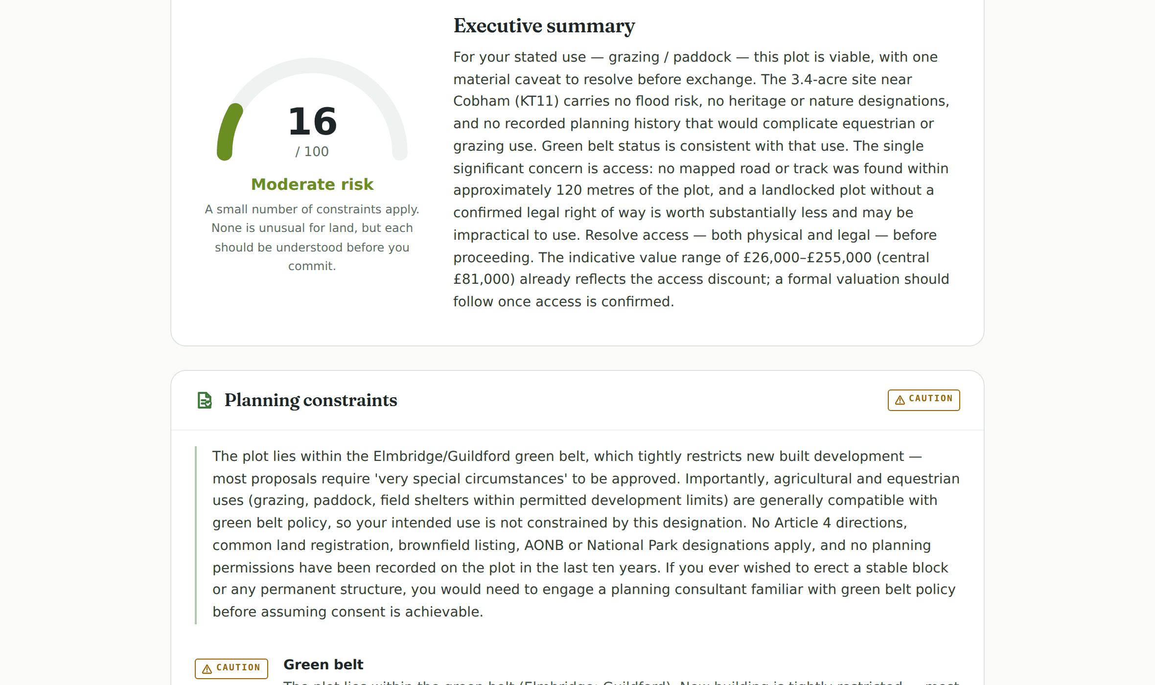
A real, anonymised report on a 3.4-acre Surrey plot: risk score, verdicts and a stamped severity on every finding.
Who runs Plot Reports
- →Self-builders comparing plots. Check each candidate before viewings, so you only pursue the ones that can actually be built on.
- →Auction buyers. The legal pack tells you what the seller must disclose. A Plot Report tells you what the data says, before bid day.
- →Anyone about to make an offer. Know the constraints and the indicative value before you name a price, not after.
- →Sellers preparing to list. See what a buyer's checks will surface and deal with it before it costs you the sale.
Where the data comes from
Every check in a Plot Report runs against an official or public dataset at the moment you order. Flood zones come from the Environment Agency. Green belt, conservation areas, listed buildings, ancient woodland, tree preservation orders and dozens of other designations come from the national planning data platform maintained by the Ministry of Housing, Communities and Local Government. Sold prices come from HM Land Registry price paid data. Planning application history comes from local authority registers. Road access is assessed against Ordnance Survey and OpenStreetMap mapping.
The point of the report is not that this data is secret. Almost all of it is public, scattered across a dozen government websites that each need their own search. The report finds the exact parcel, queries every source for that boundary, and explains what each finding means for a buyer. What would take a careful person an afternoon arrives in minutes, with the working shown.
Checks that depend on a temporarily unavailable source are marked rather than guessed. A report never fails because one government service is down, and paid reports re-check any gaps before the final PDF is produced.
Common questions
Is a Plot Report an official search?
A Plot Report compiles the official data instantly, before you commit, so you know what you're dealing with (and what to ask) while there's still time to walk away or negotiate. Your solicitor will still order official conveyancing searches if you buy.
What data does it use?
Official sources: Environment Agency flood zones, planning.data.gov.uk designations, HM Land Registry price paid data and INSPIRE title boundaries, Historic England and Natural England registers, local planning applications, and aerial imagery review. Every finding names its source.
Does it cover my plot?
Any plot in England, registered or unregistered. If the boundary is registered you can click it on the map. If not, draw it yourself and the checks run on exactly the area you draw.
A Plot Report compiles official data at the moment it runs. It is not a substitute for official conveyancing searches or legal advice, and it covers England only. Contains public sector information licensed under the Open Government Licence v3.0.